Eagle Rock Loop
The Hike
The following trail description was written by Charlie Williams at ouachitamaps.com. Weatherproof topographical maps of the trail can be purchased from Charlie. For more information on how to purchase a map click here.
The Eagle Rock Loop just may be the best hike in the Ouachita Mountains, combining rugged hill climbs through the mixed hardwood and pine forest with strolls along crystal clear streams. The loop is made of three trails and, with 5 trailheads, offers a multitude of hike options. The hardwoods in this section of the Ouachita National Forest are oak with some maple. The pines are short leaf and loblolly. In the winter, the smaller but evergreen holly trees are a striking contrast to the gray-brown of the forest floor.
This trail description goes counter-clockwise starting near the north end of the Highway 369 at the Albert Pike Recreation Area. The recreation area has been closed to camping and overnight parking since the flood of June 11, 2010.
Follow the Little Missouri Trail (white blazes) north along the Little Missouri River. The trail is fairly level but crosses the river three times and two significant tributaries making it impassible when the water is high. Call the ranger station if there has been heavy rains or take note of the water level when you cross the bridge at Albert Pike. A small hot spring has been reported in this area about 5 minutes south of the Crooked Creek crossing, between the trail and the river.
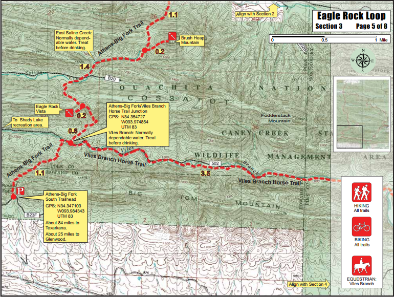
At 6.3 miles you'll come to the scenic Little Missouri Falls, its namesake picnic area and the second trailhead. The trail swings west and continues its level march along the river for another 4.1 miles and 3 more crossings. The first crossing is an old bridge and the other 2 are usually dry boulder hops. At the third trailhead the loop turns south and follows the Athens-Big Fork Trail. Over the next 4.9 miles the trail crosses four prominent east-west trending ridges formed by Ouachita thrust faulting, each with relief of 400 to 500 feet. The rocks supporting the ridges and cropping out along the river are Arkansas Novaculite, a sequence of black and near-white chert-like rocks that underlay this portion of the forest. After the fourth ridge, you'll cross Blaylock Creek and reach the trailhead on Forest Road 106 (mile 15.3). The Blaylock crossing is wide and can be done with dry feet across a long stretch of stepping stones if the water isnt too high.
There are two more ridges to cross on this section of the loop, including an 800-foot haul up Brush Heap Mountain. Look for the spur trail to Eagle Rock Vista on the second ridge taking off to the right. The vista gives you a great view of Viles valley and Big Tom Mountain to the south.
At mile 18.5 the trail drops into the valley of Viles Branch and intersects the Viles Branch Trail (yellow blazes). Turn left (east). The trail runs flat for the next 3.5 miles but crosses the creek 11 times. If the water isnt high, they are easy and dry. Watch for wild turkeys and river otter.
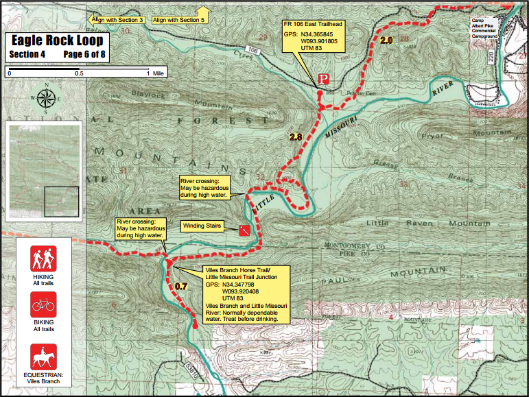
At mile 22, the Viles Branch Trail crosses the Little Missouri River and the loop rejoins the Little Missouri Trail. This is a wet crossing, year-round. Heading north you'll reach the bluff overlooking Winding Stairs, a scenic area formed by a narrow water gap through one of the novaculite ridges, and a great swimming hole. Shortly, you'll have another wet crossing across the Little Missouri, but dont put your boots back on. You are on a gravel bar and have another crossing in about 50 feet.
The fifth trailhead is the Winding Stair Trailhead located at mile 24.8. There is a short spur trail to the parking lot on FR 106. The loop finishes off with a 300-foot climb to a narrow rocky ridge overlooking Albert Pike and a steep descent to the parking lot (26.8 miles).
Water Crossings - edit
The crux of this hike are the numerous water crossings, especially the two across the Little Missouri River in the Winding Stair area. The water levels can be fatal as exemplified by the disaster of June 11, 2010 when a heavy rain sent a flash flood through the Albert Pike Recreation Area and swept 20 people to their death. Even after a normal rain, the river can be too high and swift for a safe crossing. It does comeback down in a day or so, so a rain mid-week may not affect your weekend hike. Alternatively, a downpour the night before you plan to cross may make you glad you have a map so you can bushwhack the crossings.
Here is a link to the USGS water level gauge for the Little Missouri River near Langley, AR. It will give you an idea of how fast the levels rise and fall and what is normal. As a rough coorelation, 4.0 feet and below on the guage should not be a problem if you are prudent. The water level at the Winding Stair crossings should be about calf deep. Between 4 and 4.5 feet it may be doable but there is a risk of drowning if you screw up (sounds severe but slip with your pack cinched tight and you have the makings of a tragedy). Over 4.5, you might want to wait a day, consider the bushwhack over the ridge or join the kayaks frolicking in the river at Albert Pike.
Trail Mileage Tables:
Two trail mileage tables are presented in pdf format. Both begin at Albert Pike. One is clock-wise and the other is counterclock-wise. This one is an Excel version that is interactive
Take the Journey!
Don't miss out on the next reboot challenge! Fill out the form to save your spot!
Trail Maps